Category:Brighton Station
"Black Five" steam loco 44932 at Brighton Station, 8th June 2014 [image info]
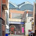
Brighton Railway Station, "BTN" (built 1840) was originally a simpler rectangular building, with an unbridged Trafalgar Street running downhill in front of it. Over the following years, the forecourt and the eastern side of the station were extended, Trafalgar Street was bridged (in three stages), and the current permanent awning with its vine-tendril design was built over the fore-area.
Other locations were considered for the terminus of the London-to-Brighton line, such as just north of Western Road, near the Brunswick Estate (residents objected). Another possible location was near the top of the the chain of green areas running up from Old Steine - putting the station in the top of this valley area would have been more convenient for visitors as it would have provided a grand route down to the most popular section of the seafront, but would have involved a more severe gradient for the track, and possibly also more difficulty in connecting with other lines. The station was finally built by excavating a vast amount of material from the hillside and creating a brick "cliff" along one side of the station track, and bridging the "dipped" area with the London Road Viaduct.
Trafalgar Street
Over the rest of the C19th, a narrow bridge was added over Trafalgar Street, and then the bridge was widened eastwards, and then widened once again. As you walk down Trafalgar Street from the West, you can see the three generations of brickwork that represent the three phases of bridge-building.
A large hotel used to stand at the area currently occupied by the bus stop area in front of the station, directly in front of Trafalgar Street. The hotel had a basement entrance on Trafalgar Street that is still visible, and (conveniently for its guests) was almost opposite the station's lower entrance.
Trafalgar Street station entrance
The old lower (disused) entrance to the station still exists on Trafalgar Street, as a square arch with 45-degree corners. This sealed-off entrance leads to the abandoned level beneath the platform of Brighton Station, which used to house baths and service businesses, with stairs emerging inside the current station area.
Disused unit
Alongside the old lower entrance is a sealed-off unit that was a barber's shop, and was then reused as a small recording studio. The next four units make up the Museum.
The Museum Arches
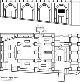
The four main arches used by the Museum are underneath the station forecourt, facing Trafalgar Road, occupying the rest of the old under-arch region. To the right of the Museum entrance is a large wooden doorway that marks the old, now-hidden entrance to the cab road that ran alongside the old station exterior wall.
The Museum's arches have been used for different purposes over the years. The smaller arched rooms that branch off the Museum lobby and are used for Museum offices and resource rooms, were originally used as stables, and each room still has a square trapdoor in the arched ceiling at the back of each room, where bales of hay were dropped down to feed the horses.
The next three arches were used to store wine or beer, and the red equilateral triangle on a white background above the outside of each arch, on Trafalgar Street corresponds to the logo of the Bass brewery company. Incidentally this logo was the very first UK registered trademark, and has the number 00001.
The section of exterior wall along the length of the museum has a mural depicting the Brighton Belle train. This was painted in 2010.
The Cab Road
Brighton Station's Cab Road ran alongside the station's original eastward exterior wall. The route was bridged-over when the station building was extended outwards to the east, and new arched units were built on its other side.
The cab road is now effectively a brick-lined tunnel that separates Brighton Toy and Model Museum from St Martin Vintners, Trafalgar Street, and from the other businesses under the newer station arches, around the corner from SMV. The entrance to the road/tunnel is behind the large wooden door directly to the right of the Museum's main entrance.
Brighton Station Goods Tunnel was used for a while as a firing range.
Brighton Works
Brighton Locomotive Works was partly situated on the adjacent land to the immediate east of the station, and was one of the country's biggest locomotive production facilities. The recent buldings to the East of the station are mostly built on the site of the old Works, and this is why many of the new place names are associated with railways (like Fenchurch Walk).
Much of this recent development is not yet listed or shown on many online maps (such as Google Maps), but can be seen on mapping websites in "satellite view".
Queens Road
Queens Road runs directly away from the station to the Clock Tower, after which it continues down to the sea, as West Street.
The upper part of Queens Road was built for access to the station, and since the station was so high up, and built on land that had been cut out of the hillside, the construction of the upper part of the road involved some compromises. In the middle of Queen's Road there is a short stretch of buildings opposite the gardens, which have a very high pavement with railings. In order to raise the level of the road, the pavement now runs in front of what were orignally the buildings' first floor levels, with their original ground floor frontages now being underground. These were connected to the gardens by tunnels running under Queens Road.
Other external references
- Basil K. Cooper Rail Centres: Brighton (Ian Allan, 1981, 1991) ISBN 0711011551
- Image of Brighton Station, in its original configuration (schoolnet.co.uk)
- Images of England
Subcategories
This category has the following 12 subcategories, out of 12 total.
B
- Brighton Greenway (1 P, 8 F)
- Brighton Station Cab Road (13 F)
H
L
- London Road Viaduct (5 F)
O
- Ouse Valley Viaduct (1 P, 6 F)
Q
S
T
Pages in category ‘Brighton Station’
The following 8 pages are in this category, out of 8 total.
Media in category ‘Brighton Station’
The following 53 files are in this category, out of 53 total.
- Anthony Dowsett, Community Rail Partnership (LatestTV 2018-03-21).jpg 960 × 541; 203 KB
- Brighton Belle Mural, early sketch.jpg 1,173 × 683; 126 KB
- Brighton Belle plaque.jpg 2,048 × 1,536; 565 KB
- Brighton From the Terminus (Railway Chronicle Travelling Chart, ~1846).jpg 4,494 × 1,650; 1.79 MB
- Brighton Greenway approach, seating and Brighton Station (June 2016).jpg 2,000 × 1,334; 669 KB
- Brighton Railway Station building, clock.jpg 2,200 × 1,467; 1.73 MB
- Brighton Station (stained glass at Brighton Palace Pier).jpg 1,600 × 1,600; 219 KB
- Brighton Station approach (Brighton Greenway, April 2016).jpg 2,500 × 1,667; 2.93 MB
- Brighton Station cliff.jpg 2,000 × 1,500; 1.15 MB
- Brighton Station enamelled sign.jpg 3,000 × 1,001; 446 KB
- Brighton Station girderwork.jpg 2,000 × 1,500; 574 KB
- Brighton Station interior, engraving (NGB 1885).jpg 1,600 × 1,080; 526 KB
- Brighton Station plaques (NLR 2014-09).jpg 1,729 × 2,400; 1.23 MB
- Brighton Station, approach, 2011.jpg 2,106 × 1,099; 482 KB
- Brighton Station, cliffview, 2011.jpg 2,000 × 1,500; 1.71 MB
- Brighton Station, David Mocatta building, rear.jpg 1,024 × 683; 499 KB
- Brighton Station, roof interior, 2011.jpg 1,632 × 915; 343 KB
- Brighton Terminus, lineart (1870s).jpg 1,024 × 605; 455 KB
- Brighton Terminus, lineart (~1840s).jpg 1,024 × 657; 413 KB
- Brighton Toy and Model Museum entrance, seen from Frederick Place.jpg 1,000 × 1,000; 770 KB
- BTMM Brighton Station Poster, layout (BrightonStation 2019).jpg 2,121 × 3,000; 961 KB
- Cab Road 011 (UnderBrightonStation 2018-01-18).jpg 3,000 × 2,000; 3.16 MB
- Cab Road 018 (UnderBrightonStation 2018-01-18).jpg 3,000 × 2,000; 2.9 MB
- Cab Road 019 (UnderBrightonStation 2018-01-18).jpg 3,000 × 2,000; 2.34 MB
- Cab Road 020 (UnderBrightonStation 2018-01-18).jpg 3,000 × 2,000; 3.35 MB
- Cab Road 021 (UnderBrightonStation 2018-01-18).jpg 3,000 × 2,000; 2.77 MB
- Cab Road 022 (UnderBrightonStation 2018-01-18).jpg 3,000 × 2,000; 3.48 MB
- Cab Road used for an art exhibition (NLR 282 2023-10).jpg 2,110 × 3,000; 1.32 MB
- Cab Road, view in (UnderBrightonStation 2018-01-18).jpg 3,000 × 2,000; 3.07 MB
- Cab Road, view out (UnderBrightonStation 2018-01-18).jpg 3,000 × 2,000; 2.48 MB
- Cab Road, view out, deeper (UnderBrightonStation 2018-01-18).jpg 3,000 × 2,000; 2.55 MB
- Catherine Simmons, Community Rail Partnership (LatestTV 2018-03-21).jpg 960 × 540; 232 KB
- Central Station, Brighton, postcard (BootsPelham 136907).jpg 3,000 × 1,905; 3.04 MB
- Central Station, Brighton, postcard detail (BootsPelham 136907).jpg 1,800 × 1,347; 1.41 MB
- Central Station, Queens Road, Brighton, PC 71 (Pictorial Centre 1910s).jpg 3,216 × 2,044; 4.21 MB
- Chris Littledale, Community Rail Partnership (LatestTV 2018-03-21).jpg 960 × 539; 140 KB
- Community Rail Partnership, signing event (2018-03-21).jpg 2,200 × 1,653; 1.61 MB
- Fenchurch Walk Brighton plaque 7 of 7.jpg 1,078 × 1,229; 208 KB
- Goods Tunnel with rooms (UnderBrightonStation 2018-01).jpg 3,000 × 2,000; 3.6 MB
- Intersection of the Cab Road and Goods Tunnel (UnderBrightonStation 2018-01-18).jpg 3,000 × 2,000; 3.82 MB
- John Peel mural, Frederick Place, 2011.jpg 2,200 × 1,650; 580 KB
- Kemp Town Line, Southern Railway, map (BrightonHbk 1939).jpg 2,998 × 3,000; 5.34 MB
- Rifle Range, back view (UnderBrightonStation 2018-01).jpg 3,000 × 2,000; 2.93 MB
- Southern Electric train in Brighton Station (MM 1936-05).jpg 1,800 × 1,293; 700 KB
- Stairs to platform level (UnderBrightonStation 2018-01).jpg 2,400 × 3,000; 2.49 MB
- Steam locomotive 44932 at Brighton Station, 8-June-2014.jpg 2,200 × 1,238; 1.88 MB
- TheBrightonBelle book.jpg 400 × 456; 42 KB
- Wartime offices, Goods Tunnel (UnderBrightonStation 2018-01).jpg 3,000 × 2,532; 3.15 MB
- William Ranieri, Community Rail Partnership (LatestTV 2018-03-21).jpg 960 × 541; 179 KB


